
West Virginia
- Area:
- Area: 24,231 sq.mi (62,758 sq.km.), 41st
- Land: 24,087 sq.mi. (62,385 sq.km.), 41st
- Water: 145 sq.mi. (376 sq.km.), 50th
- Border States:
- Climate:
- County Profile:
West Virginia County Map , 55 Counties
- Geographic Center:
Braxton, 4 miles east of Sutton
- Highest Point:
Spruce Knob ; 4,863 feet, (1,482 m.) 24th tallest
- Location:
- Absolute Center: 38°35.9’N / 80°42.2’W
- Relative Center: Braxton, 4 miles east of Sutton
- Distance Between U.S. Cities
- Lowest Point:
West Virginia; 240 feet, 30th lowest
- Maps:
- National Forest:
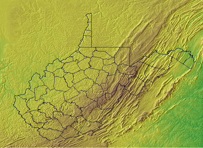
- Topography:
Image | | Ranging from hilly to mountainous; Allegheny plateau, in the west, covers two-thirds of the state; mountains over 4,000 feet.
- Weather:
- Community and Technical Colleges:
- Nursing Schools:
- School Directory:
- Biographies:
- Community Pages:
- Current Events:
- Media:
- Newspapers:
- Sports:
- Yellow Pages:
- Economy:
- Agriculture: Cattle, dairy products, poultry, apples.
- Industry: Chemical products, mining, primary metals, stone, clay, and glass products, tourism.
- White Pages:
- Internet Service Providers:
- Real Estate:

- Admission to Statehood:
June 20, 1863 (35th State)
- Area:
- Area: 24,231 sq.mi (62,758 sq.km.), 41st
- Land: 24,087 sq.mi. (62,385 sq.km.), 41st
- Water: 145 sq.mi. (376 sq.km.), 50th
- Constitution:
West Virginia’s Constitution , 35th State
- Capital City:
- Nickname:
- Population (2019):
1,854,304; Rank: 38 of 50 | Population Quick Facts
- Area Codes:
- Bird:
- Capital City:
- City Guides:
- Constitution:
West Virginia’s Constitution , 35th State
- Fast Facts:
- Flag:

A white field is bordered in dark blue. West Virginia’s flag displays a rock containing the date June 20, 1863, the day West Virginia became a state. The two men represent farming and mining. Below them are two rifles with a “Liberty Cap” on top the rifles. A banner ribbon includes the state motto “Mountaineers Are Always Free”. Around the picture are a wreath of rhododendron and the name of the state on a red ribbon. Get this Flag - Flower:
Rhododendron (Rhododendron maximum) | Other State Flowers
- Largest Cities:
Charleston | Huntington| Morgantown | Wheeling | Weirton | Fairmont | Beckley | Martinsburg | Clarksburg
- Nickname:
- Origin of State Name:
Named after England’s Queen Elizabeth I, the “Virgin Queen”
- Population (2019):
1,854,304; Rank: 38 of 50 | Population Quick Facts
- Soil:
Monongahela
- Song:
- “West Virginia Hills” | Words by: Ellen King | Music by: H.E. Engle
- “West Virginia, My Home Sweet Home” | Words by: Col. Julian G. Hearne, Jr | Music by: Col. Julian G. Hearne, Jr
- “This Is My West Virginia” | Words by: Iris Bell | Music by: Iris Bell
- “Take Me Home Country Roads” | Words by: Bill Danoff, Taffy Nivert, and John Denver | Music by: Bill Danoff, Taffy Nivert, and John Denver
- Other State Songs | Sheet Music
- State Quarter:
- Symbols:
- Tree:
Sugar Maple (Acer saccharum) | Other State Trees
- Zip Codes:
- Capital Tour:
- County Profile:
West Virginia County Map West Virginia County Map , 55 Counties
- Courts:
- Department of:
- Driving:
- Highway Markers:
- Local Resources:
- Public Records:
- Representatives:
- Roadside America:
- Vital Records: