
Arizona
- Location:
- Absolute Center: 34°18.5’N / 111°47.6’W
- Relative Center: Yavapai, 55 miles east southeast of Prescott
- Distance Between U.S. Cities
- Lowest Point:
Arizona; 70 feet, 26th lowest
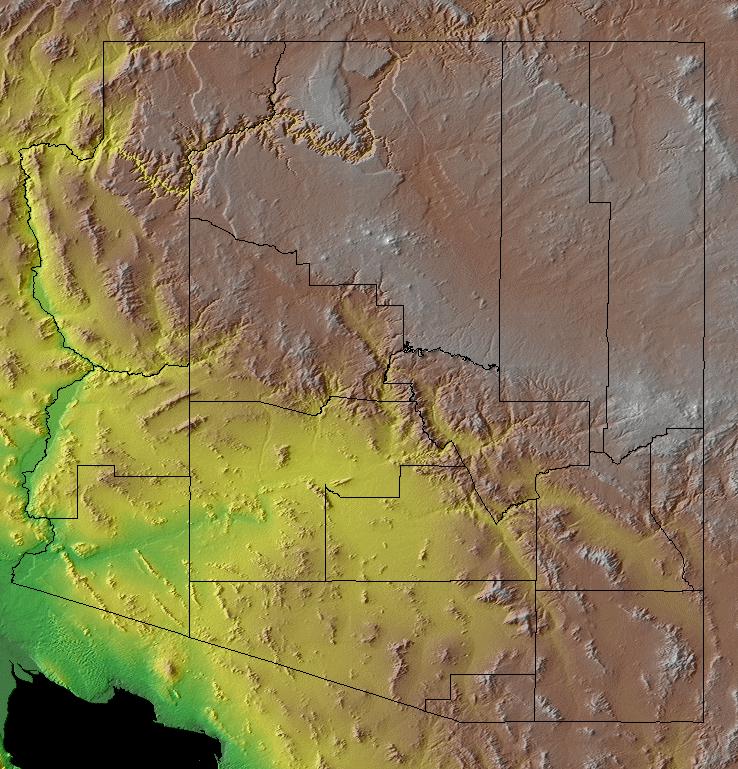
- Maps:
- National Forest:
- Topography:
Image | | Colorado plateau, containing the Grand Canyon; Mexican Highlands and Sonoran Desert
- Weather:
- Community and Technical Colleges:
- Nursing Schools:
- School Directory:
- Biographies:
- Community Pages:
- Current Events:
- Media:
- Newspapers:
- Sports:
- Yellow Pages:
- History:
- Economy:
- Agriculture: Cattle, cotton, dairy products, lettuce, nursery stock, hay.
- Industry: Copper and other mining, electric equipment, transportation equipment, machinery, printing and publishing, food processing, electronics, tourism.
- White Pages:
- Internet Service Providers:
- Real Estate:
- Unclaimed Funds:

- Admission to Statehood:
February 14, 1912 (48th State)
- Area:
- Area: 114,006 sq.mi (295,274 sq.km.), 6th
- Land: 113,642 sq.mi. (294,332 sq.km.), 6th
- Water: 364 sq.mi. (943 sq.km.), 48th
- Constitution:
Arizona’s Constitution , 48th State
- Capital City:
- Nickname:
- Population (2019):
6,626,624; Rank: 15 of 50 | Population Quick Facts
- Area Codes:
- Bird:
- Capital City:
- City Guides:
- Constitution:
Arizona’s Constitution , 48th State
- Fast Facts:
- Flag:
 The 13 rays of red and gold on the top half of the flag represent both the 13 original colonies of the Union, and the rays of the Western setting sun. Red and gold were also the colors carried by Coronado’s Spanish expedition in search of the Seven Cities of Cibola in 1540. The bottom half of the flag has the same Liberty blue as the United States flag. Since Arizona was the largest producer of copper in the nation, a copper star was placed in the flag’s center. Flag adopted 1917. Learn More About This Flag | Order This Flag
 - Flower:
Saguaro cactus blossom (Carnegiea gigantea) | Other State Flowers
- Largest Cities:
- Nickname:
- Origin of State Name:
Based on the Basque word aritz onak meaning “good oak” or the Spanish word Arizonac meaning “having a little spring”
- Population (2019):
6,626,624; Rank: 15 of 50 | Population Quick Facts
- Soil:
Casa Grande
- Song:
- “Arizona” | Words by: Margret R. Clifford | Music by: Maurice Blumenthal
- Other State Songs | Sheet Music
- State Quarter:
- Symbols:
- Tree:
Yellow Palo Verde (Parkinsonia microphylla) | Other State Trees
- Zip Codes:
- Capital Tour:
- County Profile:
Arizona County Map Arizona County Map , 15 Counties
- Courts:
- Department of:
- Driving:
- Highway Markers:
- Local Resources:
- Public Records:
- Representatives:
- Roadside America:
- Vital Records:
- Area:
- Area: 114,006 sq.mi (295,274 sq.km.), 6th
- Land: 113,642 sq.mi. (294,332 sq.km.), 6th
- Water: 364 sq.mi. (943 sq.km.), 48th
- Border States:
- Climate:
- County Profile:
Arizona County Map , 15 Counties
- Geographic Center:
Yavapai, 55 miles eastsouth east of Prescott
- Highest Point:
Humphreys Peak ; 12,633 feet, ( 3,851 m), 12th tallest
- Area: